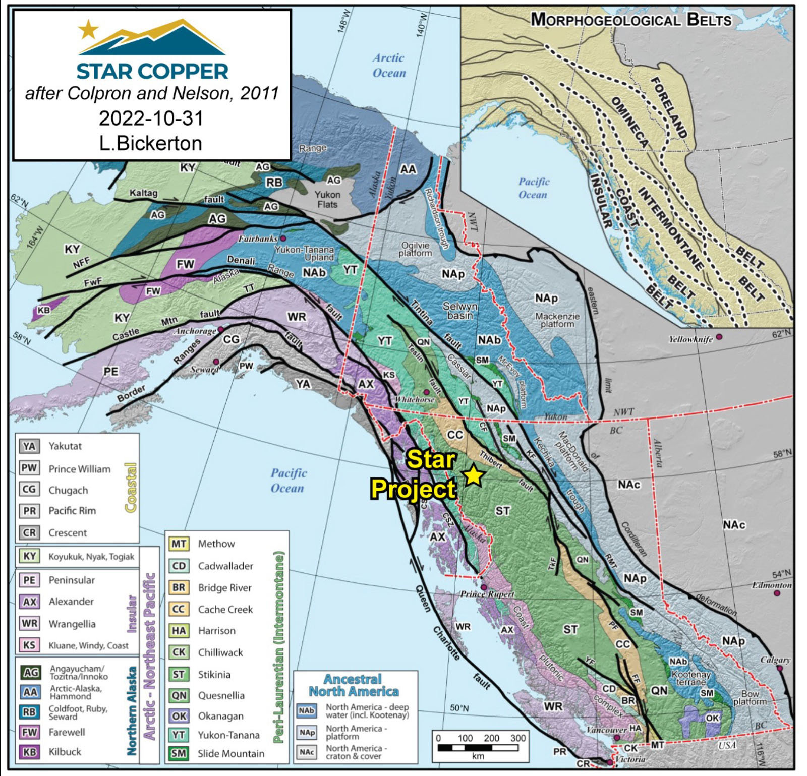
The Golden Triangle is a loosely defined region that host a significant amount of major gold, silver and copper deposits in northwestern British Columbia.*
The Star target is an advancing copper-gold system with potential for extension both laterally and at depth. Additional high priority targets, backed by geochemical and geophysical anomalies remain untested and have potential for discovery of new mineralization.
Our flagship Star Project is an intermediate calc-alkaline to alkalic porphyry deposit. It is located within the well-known Golden Triangle and Golden Horseshoe regions of British Columbia in an exceptionally prolific area for porphyry copper-gold projects.
100% owned for first time in the ~70 year history of the project.
Multi-year permit (Area based (MYAB) Notice of work permit in hand.
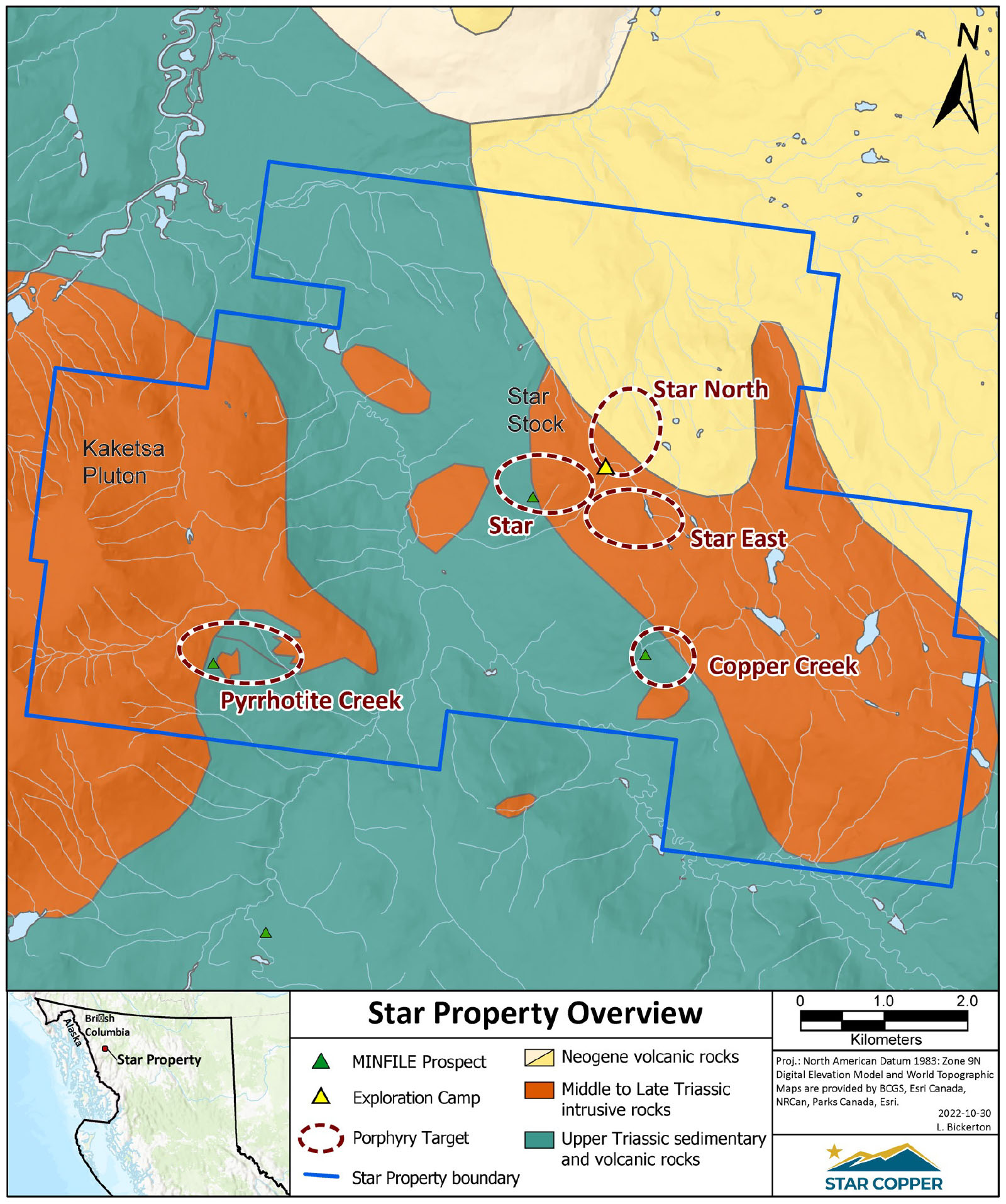
6,829 Ha copper porphyry project, 100 km west-southwest of Dease Lake, BC.
Multiple mineralizing intrusive phases, form a steep dipping pipe like structure.
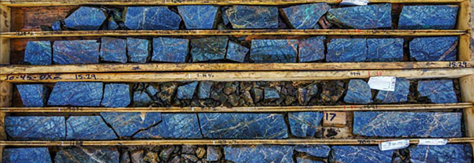
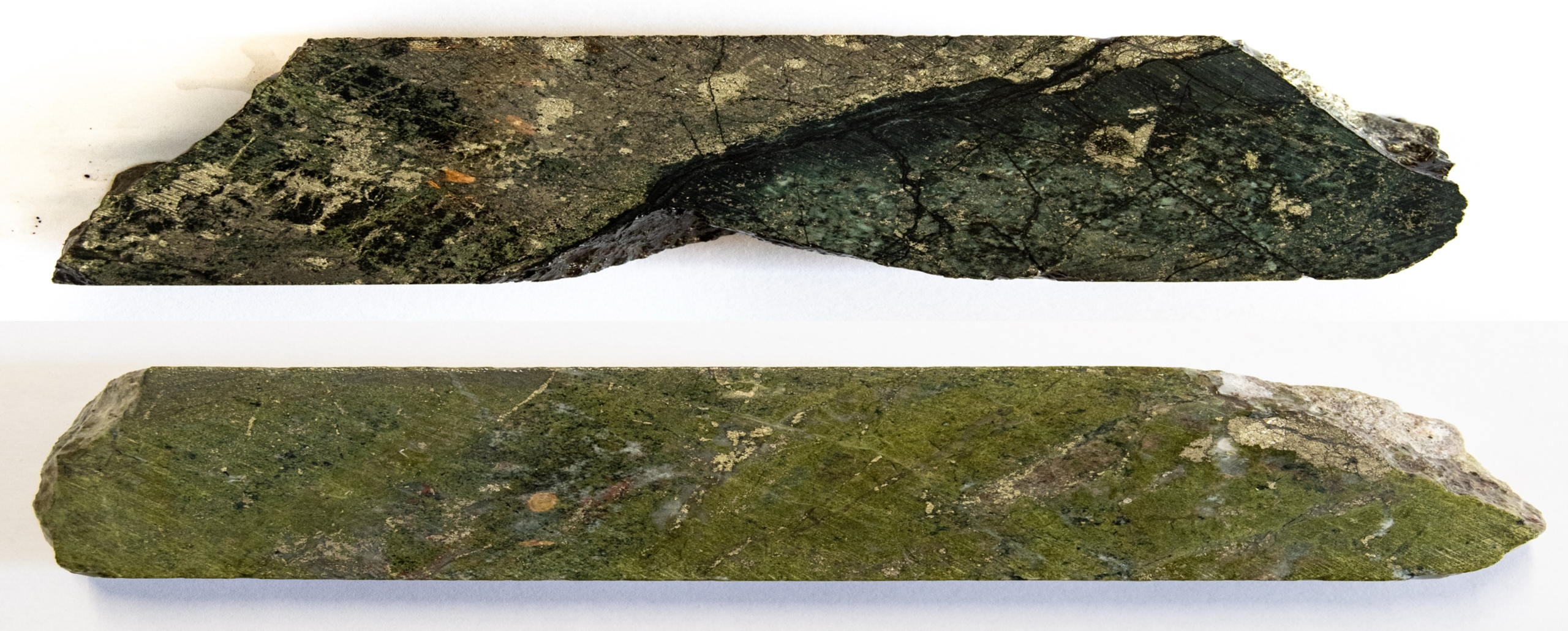
Core Box SO45 1-2 12.62-18.20m – Click/tap image to enlarge
OVERVIEW
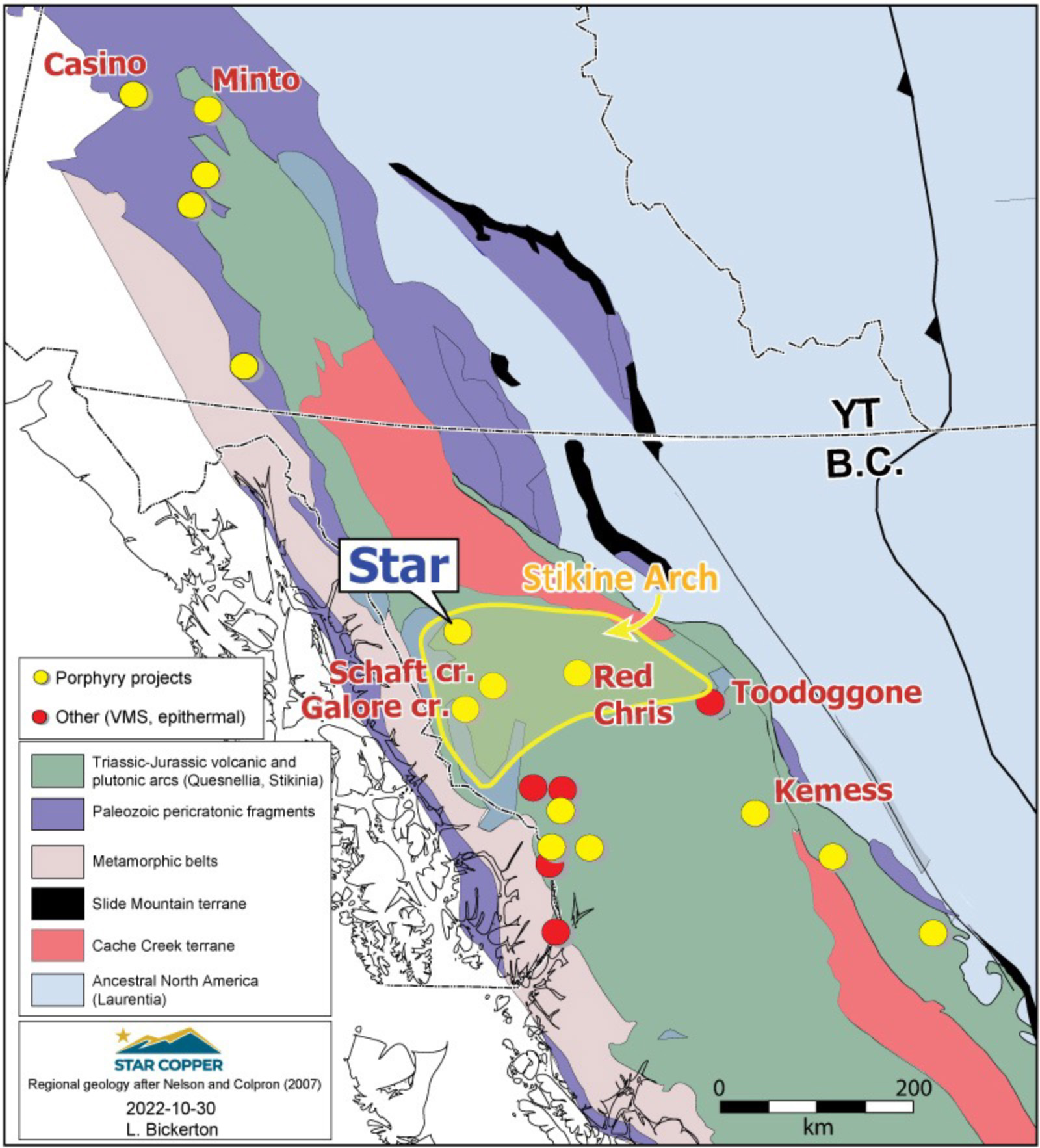
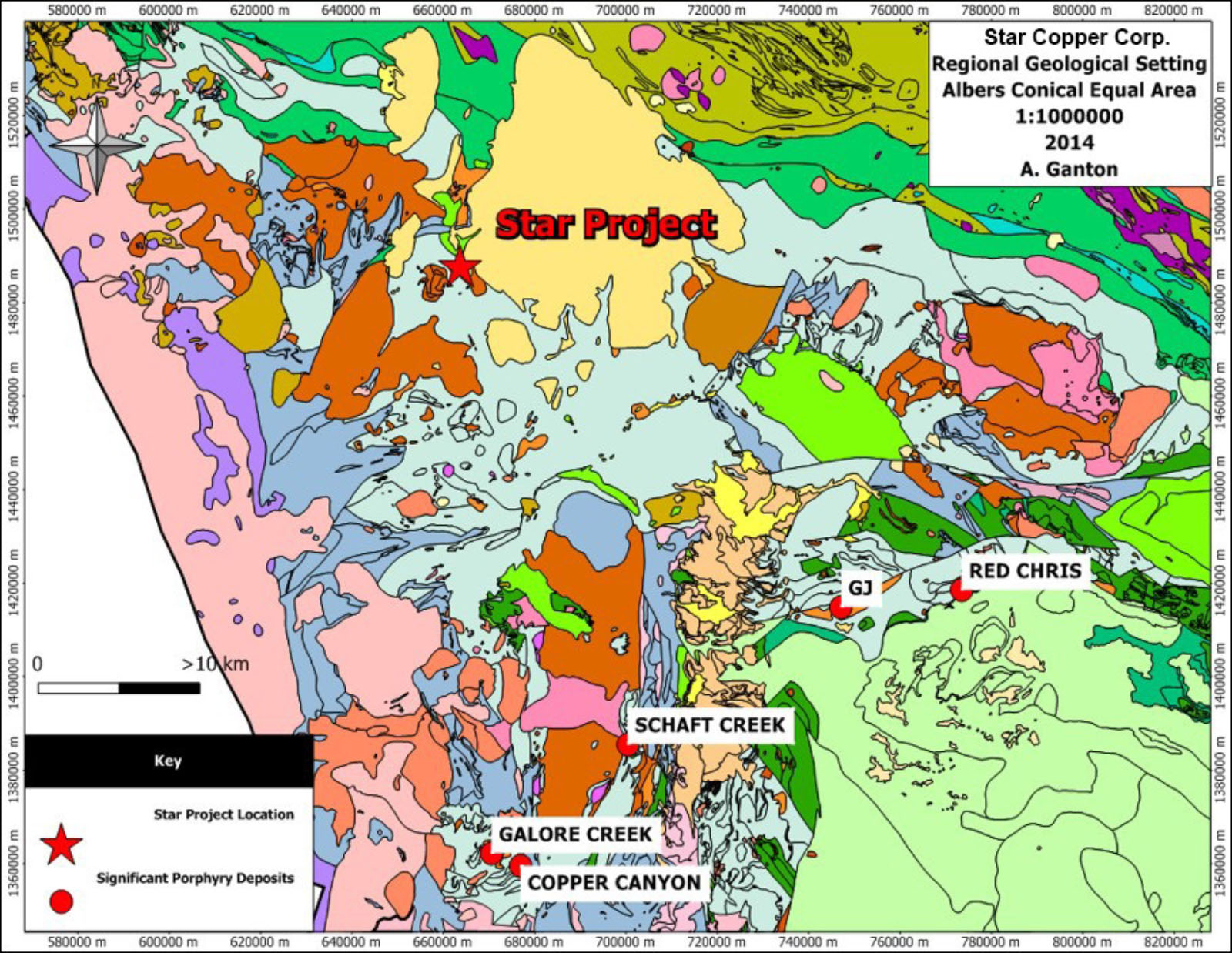
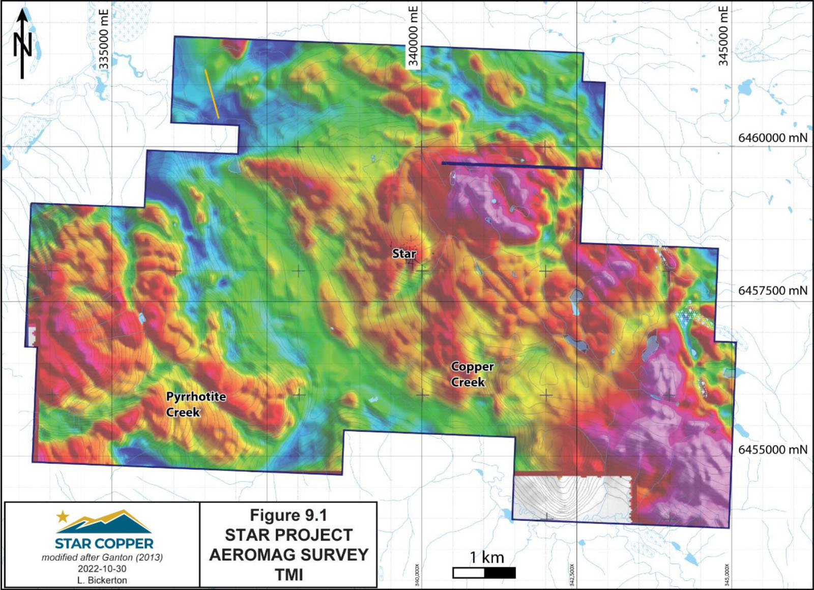
The Star Copper project is located west- southwest of Dease Lake in an area known as the “Stikine Arch,” an important mineral district in northern British Columbia.
The Stikine Arch
Encompasses the northern Stikine terrane, an area that hosts prolific porphyry, volcanogenic massive sulphide, and high-grade vein deposits.
Includes the presently producing Red Chris and Brucejack mines.
Past-producing Eskay Creek, Snip, Granduc, Silbak Premier and Scottie Gold mines.
Also hosts large undeveloped deposits such as Galore Creek, Schaft Creek, Kerr, Sulphurets, Mitchell, Snowfield and Iron Cap porphyry deposits.
Work has been conducted on the Star property since its discovery in 1937. Each program outlined below has returned positive results indicating high potential for significant copper-gold mineralization.
1937 – Copper Creek showing discovered through prospecting
2013-14 (Prosper Gold) – 26 diamond drill holes (9001.3 m) Star target, 3 diamond drill holes (963.9 m) Pyrrhotite Creek, 1 diamond drill hole (136.9m) Star East. Geochem, IP, Aeromag, Prospecting, Mapping.
2025 (Star Copper) – 2 phase drill program composed of ~4700m diamond drilling.
2026 (Star Copper) – Planned 3D IP and MT survey with Quantec to tighten geophysical models.
2026 (Star Copper) – 10,000 + m.
Star Copper Region 2025 Click/tap image to enlarge.
PROPERTY
The Star Project consists of 19 contiguous mineral claims totaling 68.29 square kilometers (6,829ha) on Crown Land (Atlin Mining Division) administered by the Province of British Columbia and located in the Traditional Territory of the Tahltan Nation and the Taku River Tlingit First Nations
Located approximately 50 km northwest of the community of Telegraph Creek, BC.
The property straddles the Hackett River valley.
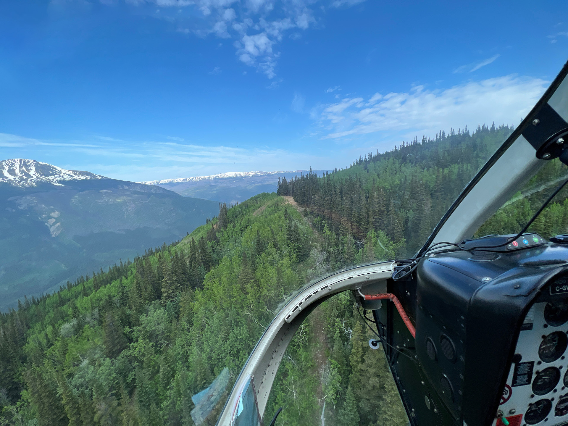
Access is by helicopter, or to a private airstrip in NW corner of the claims.
An all-weather road is approximately 8 km to the west.
A permanent outfitters camp is well equipped and suitable for housing.
All known zones of mineralization are accessible by way of historic cat roads or ATV trails.
Click/tap image to enlarge.
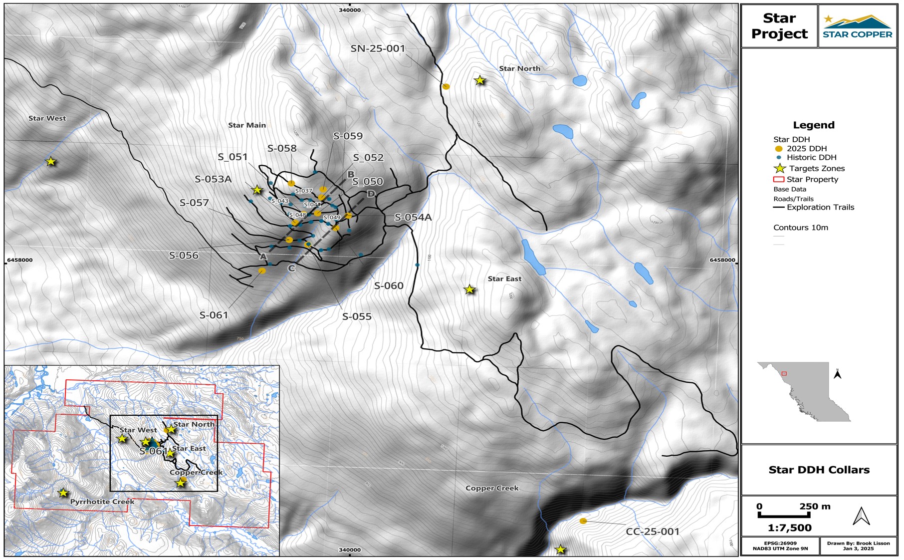
There are five significant high priority targets on the Property (click tabs to review):
Star Project Drilling – View to NNW. Click/tap image to enlarge.
Drill Collars - Click to Enlarge
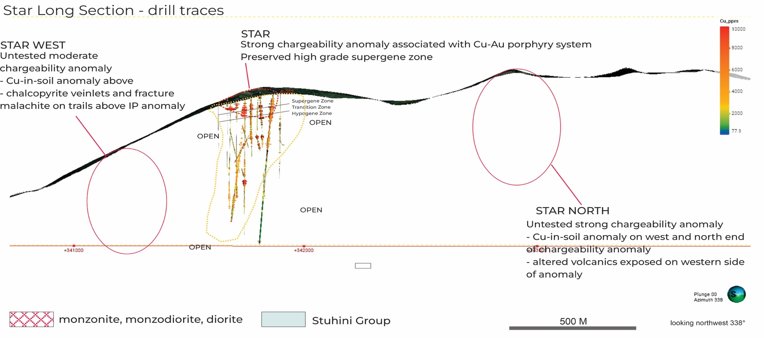
Drill Traces - Click to Enlarge
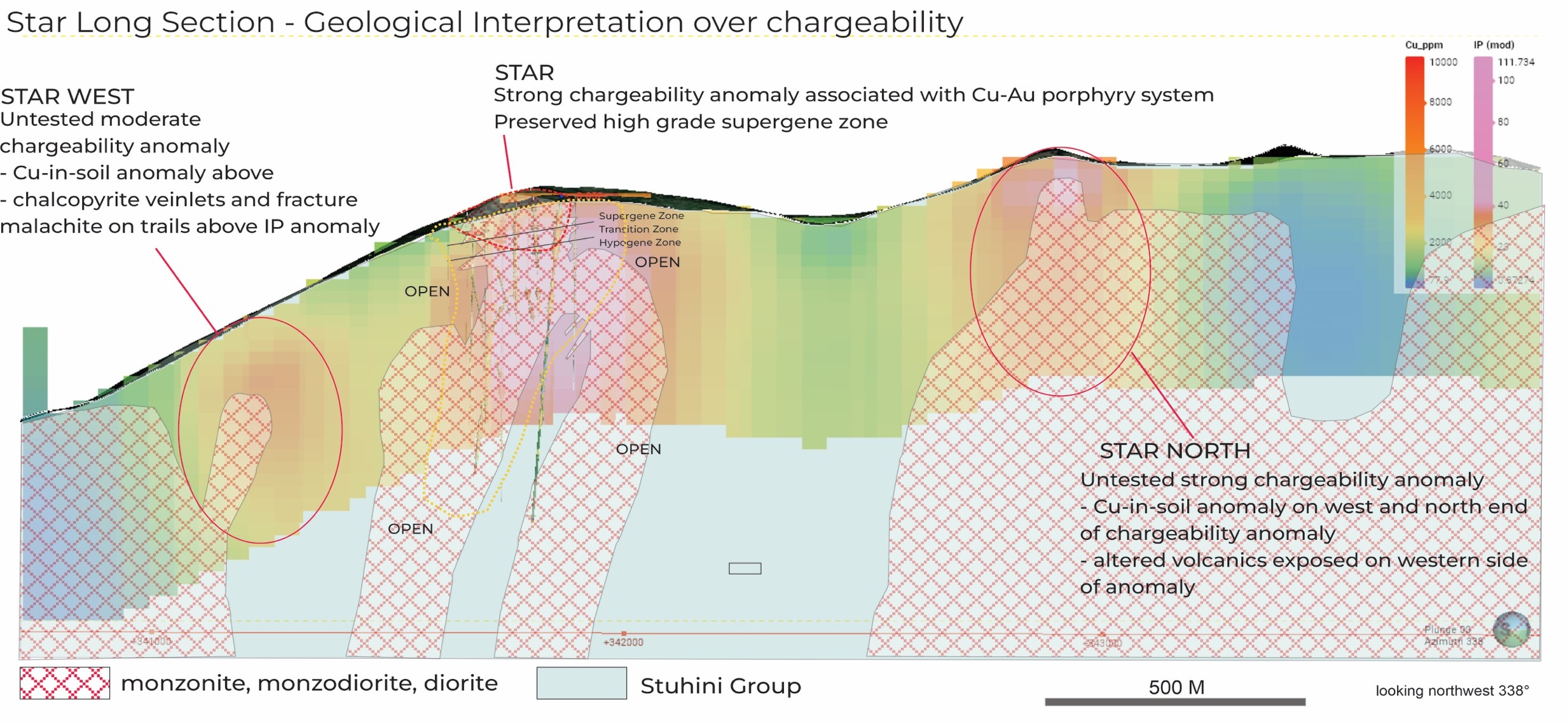
IP Chargeability - Click to Enlarge
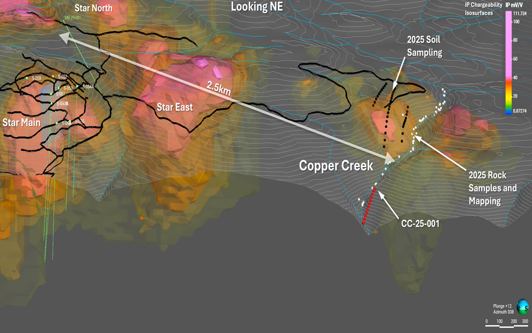
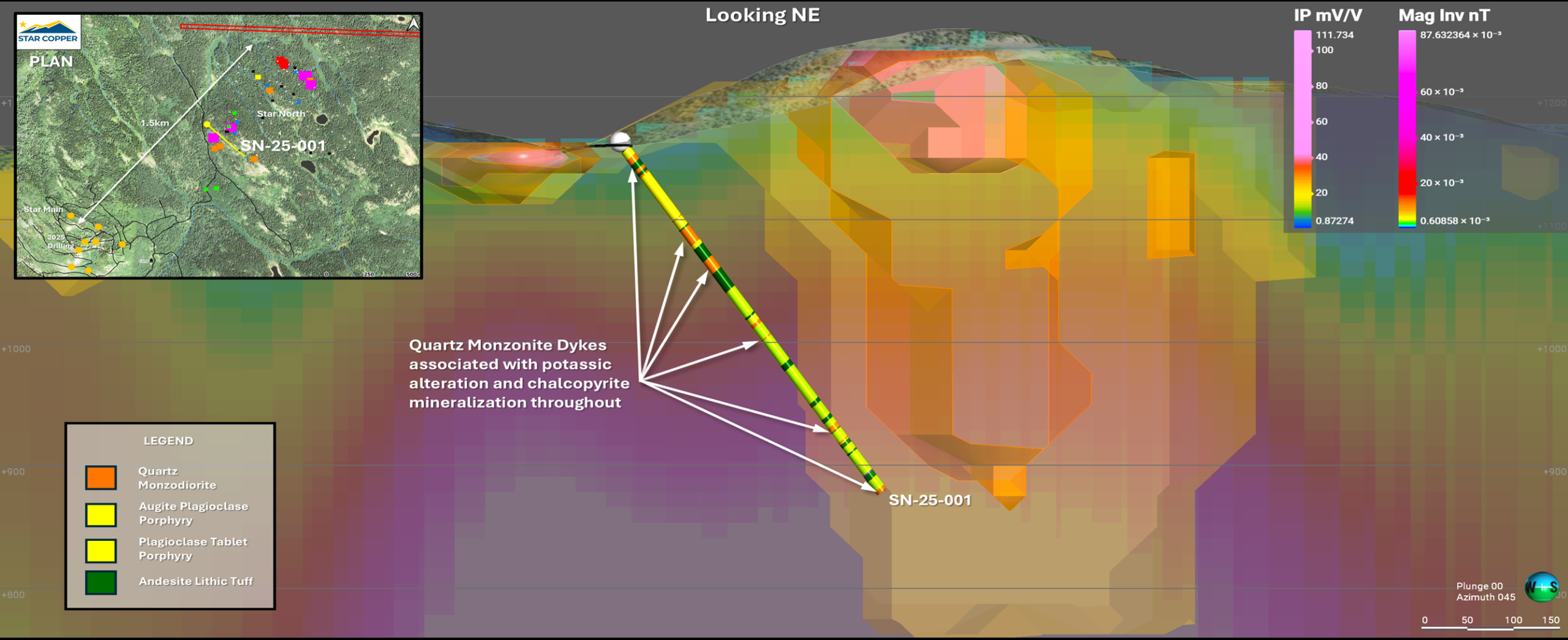
The Star North target is located approximately 1000m northeast of the Star porphyry
2015 prospecting uncovered new areas of mineralization consisting of chalcopyrite veins and disseminations within quartz monzodiorites with mal+az staining over 350+m, fine grained bornite in float
Characterized by a strong positive magnetic and IP chargeability anomaly
Positive copper and gold soil anomalies (500 x 700 m, open for extension).
No history of drilling or surface trenching, and the area separating this target from the main Star target remains unexplored.
Geologic confirmation hole drilled to test the chargeability anomaly, further drilling planned for 2026
Click/tap image to enlarge.
Star North Target - Click to Enlarge
Located approximately 1000 m east-southeast of the Star porphyry discovery
Historical surface samples have grades as high as 0.40% Cu, although these samples were not analyzed for Au.
500 x 500 m strong positive copper and gold soil anomalies
IP chargeability high.
Limited trenching uncovering low grade propylitic rocks with copper staining,
1 short drill hole (137m) intercepted short intervals of copper mineralization (4 and 6m of 0.17 and 0.22% Cu)
Very limited outcrop
Click/tap image to enlarge.
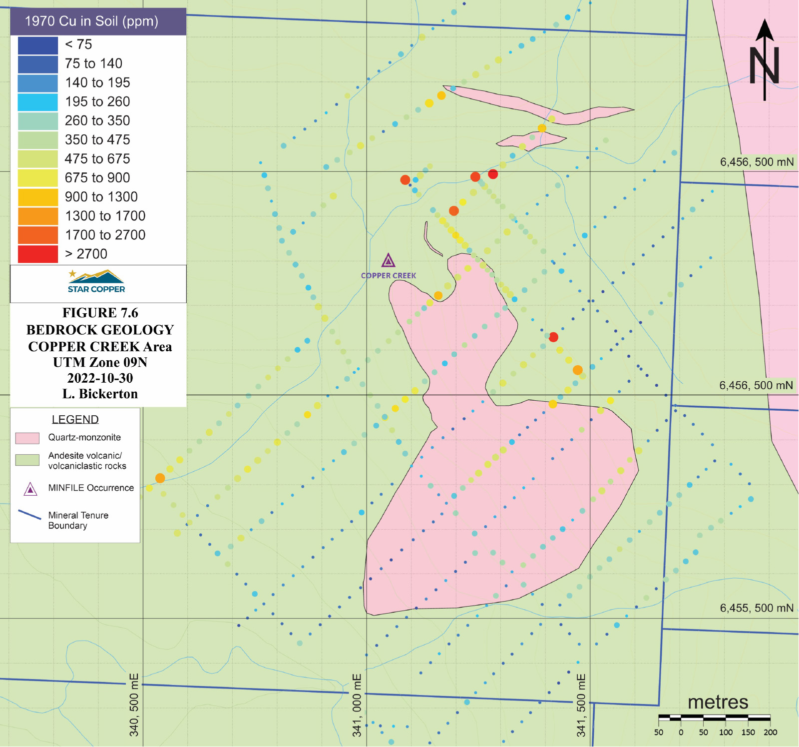
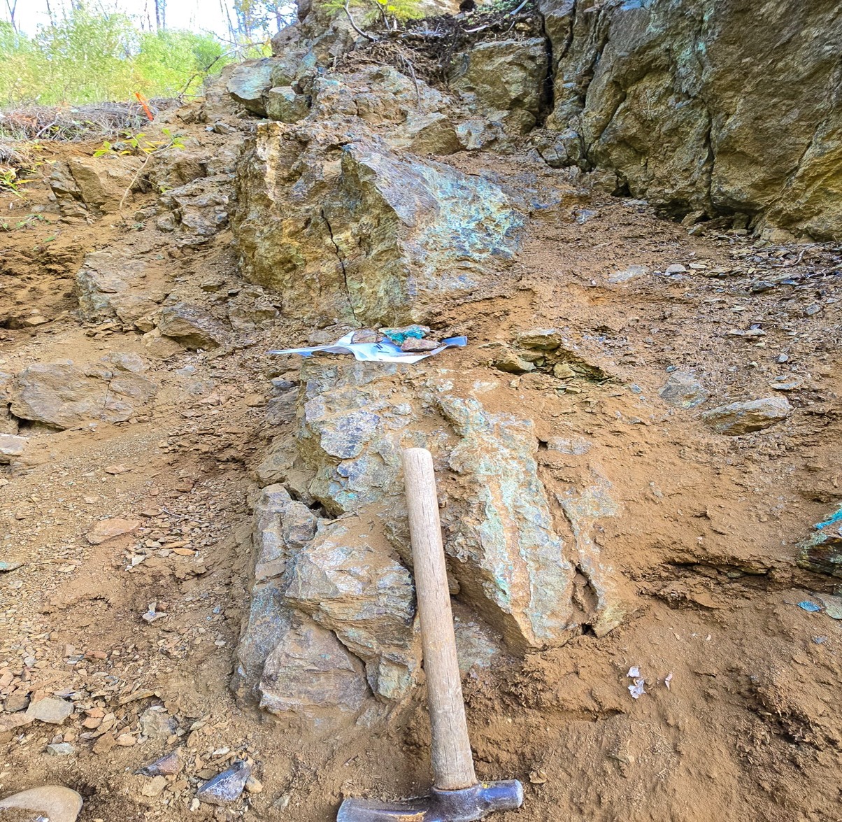
The Copper Creek target is the initial (1937) discovery showing on the property
Centered on an impressive gossan in the walls of Copper Creek characterized by extensive malachite and azurite staining
Copper and gold soil anomalies cover the target area over a 1000 x 550 m area
Geophysical anomalies that are open to the north, south and east.
Historical 6 drill holes with incomplete drill logs, including copper and minor precious metal values.
The most significant intercept from the early drilling at Copper Creek includes 43.58 m @ 0.49% Cu from 8.53 to 52.12 m in DDH G-2-70.
Drilled from a helicopter supported drill pad in 2025 confirming the historic hole and mineralization.
Click/tap image to enlarge.
Copper Creek Trench - Click to Enlarge
Copper Creek 2025 Mineralization - Click to Enlarge
Linear 1800m by 750m altered and mineralized corridor.
High copper in soil anomalies on margin of 1.2 km IP anomaly.
Historical hand trenching results of 130m @ 0.40 % Cu.
Although remote, infrastructure at the Star property suggests that exploration costs, and ultimately, capital costs to develop a deposit discovered on the property, could be significantly less than at other remote properties in northern B.C.
Darryl Jones, President & CEO
There are currently no known mineral resources or reserves of historic mining operations on the Property and no known environmental liabilities.
There are no known significant factors that may affect access, title, or the right or ability to perform work on the property.
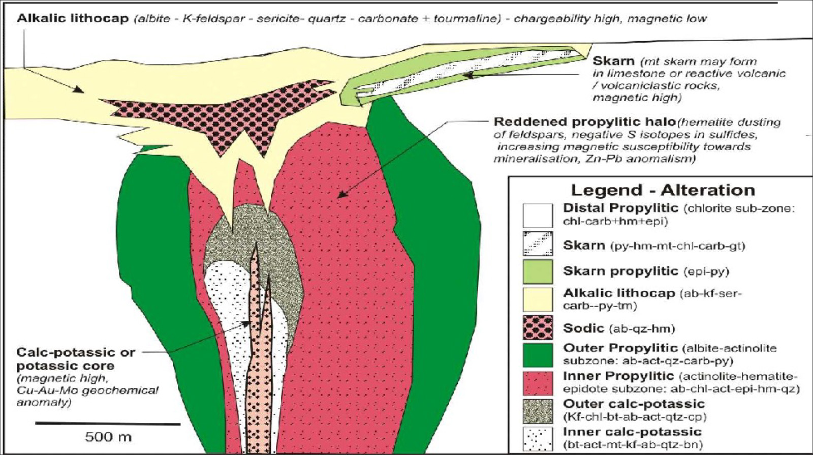
GEOLOGY
The Star project is an example of an alkalic porphyry copper-gold system.
The regional geological setting comprises island arc volcanic, marine sedimentary, and plutonic rocks of the Middle to Late Triassic Stuhini Group that forms a dominant portion of the accreted geological terrane of Stikinia in the northern Intermontane Belt of the Canadian Cordillera.
In this region, several large Late Triassic calc-alkalic to subalkalic plutons (Stikine suite), including the Kaketsa pluton and Star stock, intrude the Stuhini Group.
Click/tap image to enlarge.
Click/tap image to enlarge.
The Kaketsa pluton, in the western part of the property, is about 7 km long by 4.5 km wide at surface, and elongated in the north–south direction.
A separate intrusion of similar age intrudes the Stuhini volcanic rocks in the eastern part of the property.
Numerous dykes occur throughout the property, trending northwest-southeast.
Several faults influence patterns of mineralization and alteration by late mineral and/or post-mineral displacement.
The Star property displays typical porphyry style mineralization in supergene and hypogene settings.
The supergene zone locally extends to between 80-100 m depth and is characterized by disseminated azurite and malachite with fractures coated in tenorite.
Hypogene mineralization at the Star target is defined by vein-hosted and disseminated sulfides (i.e., chalcopyrite, pyrite, bornite, and molybdenite).
Chalcopyrite is volumetrically the most abundant copper sulfide found on the property.
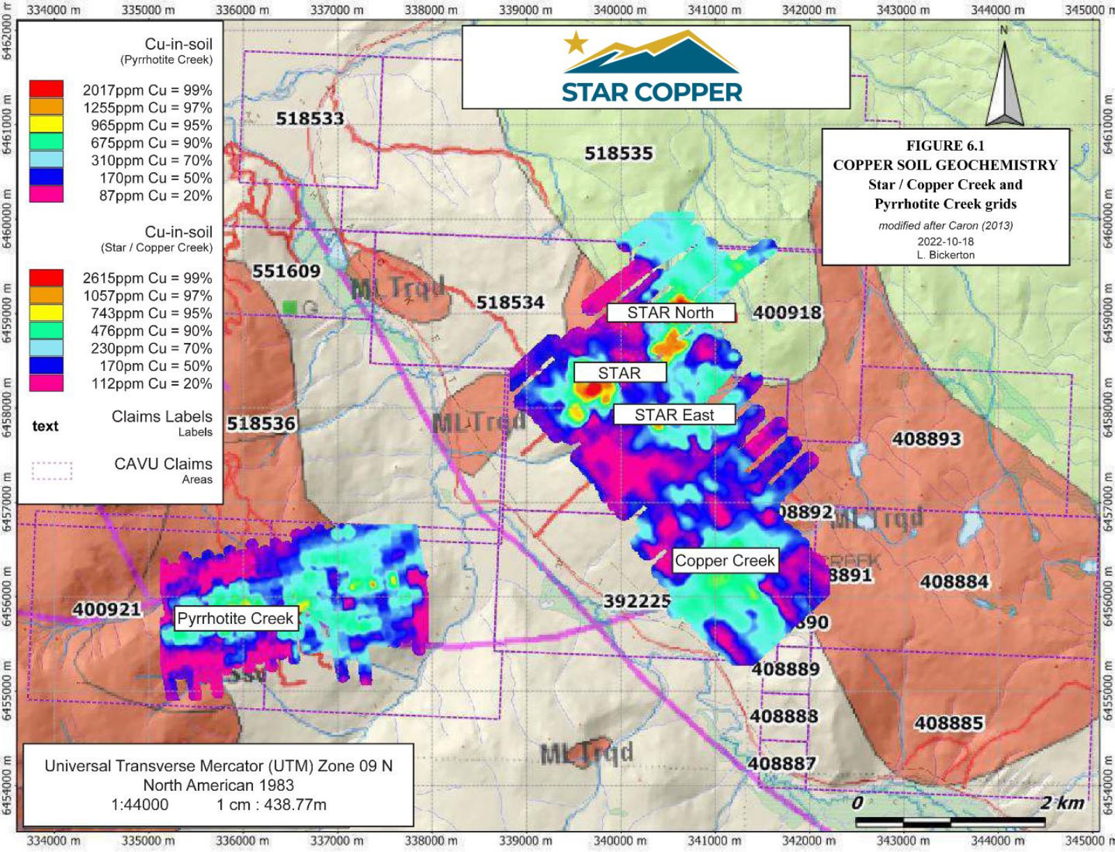
There are three main areas of copper-gold mineralization; the Star (including the Star East and Star North, Copper Creek, and Pyrrhotite Creek zones.
Mineralization is related to zones of intense fracturing near the contact of the Kaketsa and/or related intrusive rocks with the surrounding Stuhini Group volcanic and volcaniclastic rocks, and has many of the characteristics of alkalic porphyry copper-gold mineralization.
Copper Soil Geochemistry. Click/tap image to enlarge.
Click/tap image to enlarge.
There are three main areas of copper-gold mineralization; the Star (including the Star East and Star North, Copper Creek, and Pyrrhotite Creek zones.
Mineralization is related to zones of intense fracturing near the contact of the Kaketsa and/or related intrusive rocks with the surrounding Stuhini Group volcanic and volcaniclastic rocks, and has many of the characteristics of alkalic porphyry copper-gold mineralization.
Click/tap image to enlarge.
Copper Soil Geochemistry. Click/tap image to enlarge.
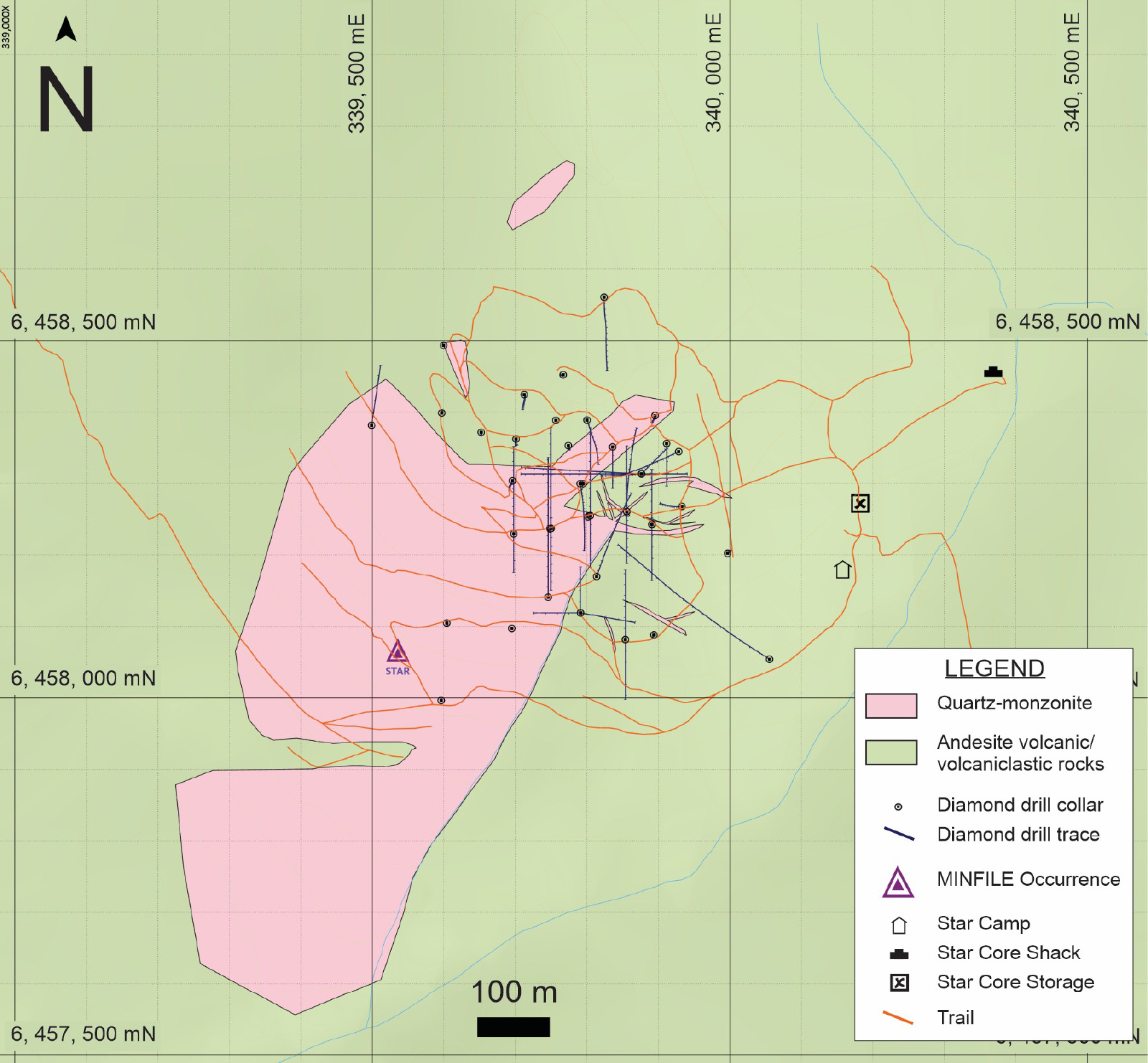
Star Deposit
The Star stock is a multi-phase intrusion, approx. 500x1000m, comprised of mineralized diorite to tonalite (including qtz-monzodiorites and monzodiorite dykes) and later unmineralized phases of monzonite including crowded pink feldspar porphyry.
The Star target is covered by a large, strong, coincident copper-gold soil anomaly that measures 500x500m.
Anomalous gold-in-soil values occur within this area and continue northeast beyond the limits of the copper anomaly.
Star Copper’s Phase 1 six-hole drill program has successfully accomplished several important tasks which include:
Confirmation of copper mineralization in multiple intrusive phases,
Refined structural and alteration models, including potassic halos and supergene enrichment,
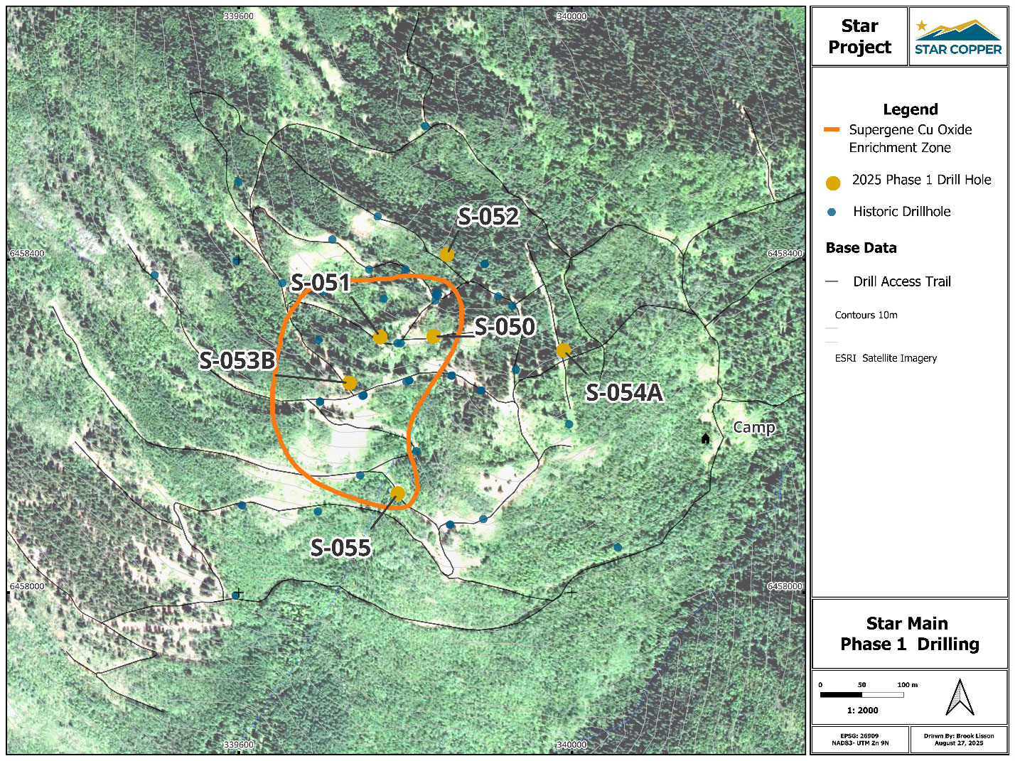
Expanded the supergene mineralized footprint at the Star Main zone up to 250m x 300m.
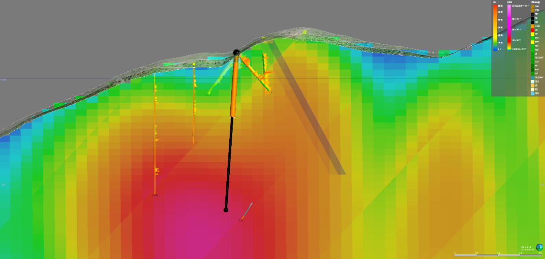
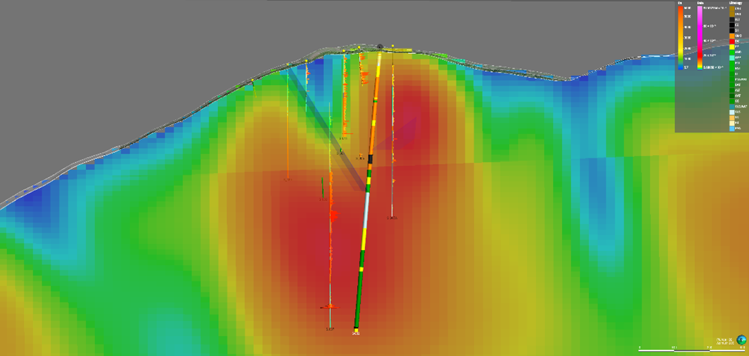
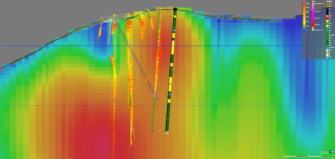
The six-hole drill campaign (see map right) consisted of target holes 2025 A-F (S-050, S-051, S-052, S-053B, S-054A, S-055) and totaled over 2200m which culminated with the recently completed Hole S-055 (2025-F) which intersected a near-surface oxide horizon with visible malachite and azurite (see news release of August 25, 2025)
Star Project Copper Oxide Zone and Phase 1 Exploration Drill Targets. Star Copper 2025 Click/tap image to enlarge.
Star Copper Drilling Highlights - Click to Enlarge
CROSS SECTION FIGURES FOR DRILL HOLES A-TO-F
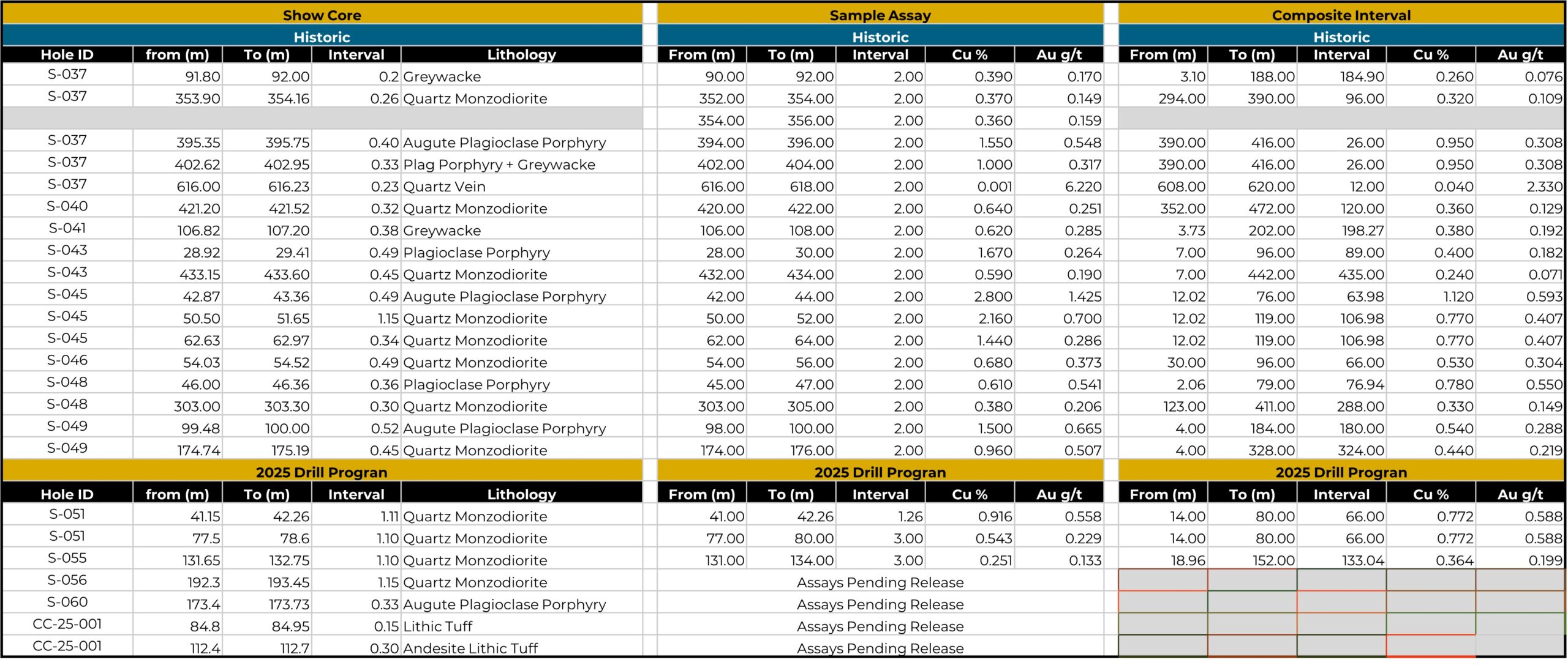
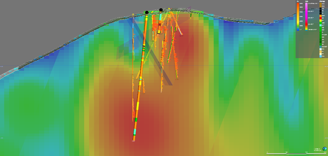
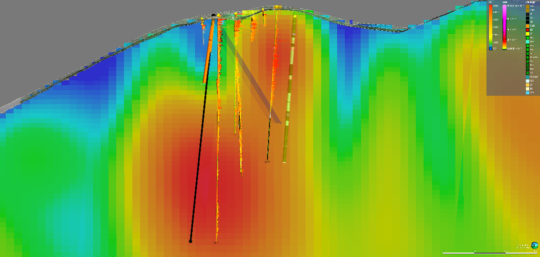
Figure 1 – Drill Holes A and B (S-050 & S-051) Click/tap image to enlarge.
Figure 3 – Drill Hole D (S-053A / S-053B) Click/tap image to enlarge.
Figure 5 – Drill Hole F (S-055) Click/tap image to enlarge.
Figure 2 – Drill Hole C (S-052) Click/tap image to enlarge.
Figure 4 – Drill Hole E (S-054A) Click/tap image to enlarge.
The Phase 1 drilling expanded the near-surface supergene footprint to the west and southwest, confirmed copper mineralization across multiple intrusive phases, and sharpened the structural and alteration framework, particularly along the Star Fault and associated potassic (K-feldspar) alteration corridors.
The supergene zone at Star Main is a particularly noteworthy prospect for Star Copper and a relatively rare find for this area of Canada., Supergene enrichment is a geological process where valuable metals are concentrated near the Earth’s surface, producing an enhanced grade of ore deposits. Hypogene mineralization involves ascending fluids from deep within the Earth. Chalcopyrite mineralization refers to the occurrence of chalcopyrite, a copper iron sulfide mineral (CuFeS2), within various geological formations and ore deposits.
The technical team is now incorporating these results into a refined 3D model to guide the follow-up Phase 2 drill program slated for the fall season of 2025. This next phase will prioritize step-outs into newly defined targets and further test structural and geochemical continuity across the broader Star property.
Qualified Person
Jeremy Hanson, P. Geo., a Qualified Person as that term is defined under NI 43-101, is an independent contractor of the Company and has reviewed and approved the technical aspects of the information above.
PREVIOUS EXPLORATION
2013 Highlights
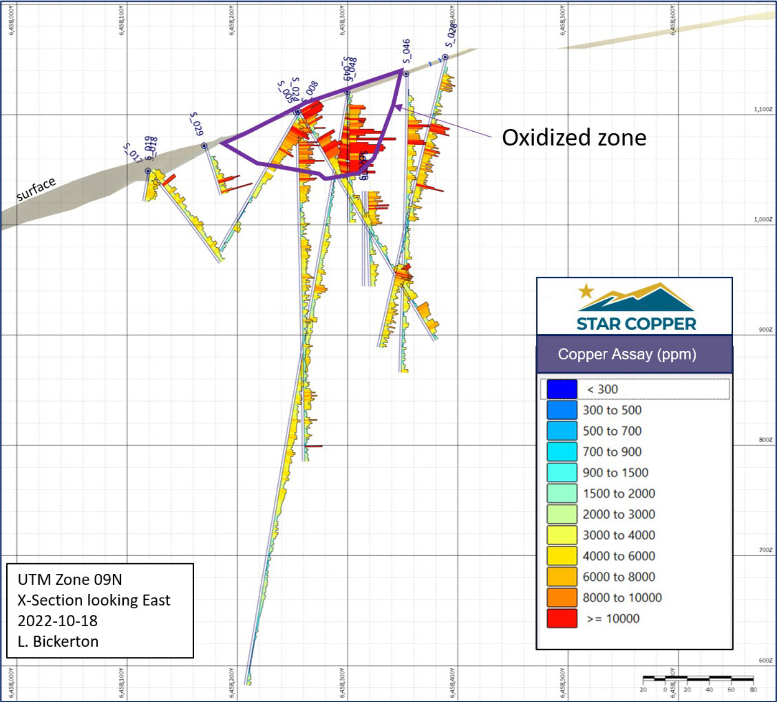
The 2013 campaign intercepted porphyry style mineralization extending beyond 500 metres before surface at the Star target.
312.16m @0.37% Cu, 0.24 g/t Au (S024)
269m @0.42% Cu, 0.198 g/t Au (S025)
263m @0.35% Cu, 0.15 g/t Au (S026)
72m from 504m to 576m @0.27% Cu and 0.10 g/t Au (S027)
2014 Highlights
20 diamond drill holes totaling 6,661.5m expanded known mineralization at Star target laterally and to depth.
Star target supergene defined as approximately 550m north-south and 350m east-west.
Phase 1 comprised six drill holes (S-050 through S-055/S-053B) focused on testing the Star Main copper-gold system, particularly the near-surface supergene (oxidized) zone and defining structural controls on mineralisation.
The program was designed to:
Confirm and expand the known supergene copper footprint,
Refine geological and structural models (potassic alteration, star fault corridors), and
Provide vectors for follow-up Phase 2 drilling.
Strong Copper-Gold Intercepts
Early released assays from three Phase 1 holes showed significant mineralisation, including:
Hole S-051: 226 m @ 0.67% CuEq from 14 m, incl. 40 m @ 1.56% CuEq in the supergene zone.
Hole S-050: 93 m @ 0.91% CuEq from 8 m near surface.
Hole S-052: 397 m @ 0.37% CuEq from 29 m, including deeper higher-grade intervals, demonstrating both oxide and hypogene mineralisation.
Deeper and Structural Insights
Later holes, such as S-053, S-054A and S-055, continued to confirm hypogene copper-gold mineralisation beneath the oxide zone, with highlighted intercepts like: 311 m @ 0.42% CuEq from 18 m (including 133 m @ 0.55% CuEq).
Drill results helped refine alteration and structural frameworks, particularly the role of the Star Fault and potassic alteration corridors in localising mineralisation.
Technical and Program Summary
Phase 1 integrated historic drilling with modern geophysics to test lateral and vertical continuity of mineralisation.
Drilling confirmed broad copper occurrence from surface oxides to deeper hypogene zones, supporting a nested porphyry model with potential for expansion.
PHASE 2 DRILLING - COMPLETE
Phase 2 Program – Complete and Awaiting Assays
A Multi-Year Area Based (MYAB) Notice of Work Permit is in Hand
Surface drilling from 200 ground and helicopter supported locations.
Camps: Up to 35 people at Star.
Mechanical trenching at 50 sites.
50 LINE km IP survey.
5 km of new exploration trail construction.
The Star Project will benefit from significant database compilation and organization to streamline historic results and interpretations.
The geologic model for the Star would benefit from a complete classification and delineation of porphyry dikes and veins.
Classifying dikes and veins from the historic data is crucial and delineation in the subsurface may explain mineralization continuity.
A structural interpretation at the Star will better define a deformational history in the region and potentially attribute mineralization, lithologies and topography to structural features.
Further IP data acquisition on the project may benefit from a deep IP survey on the main Star target as well as shallow surveys on pyrrhotite creek and copper creek.
For the less developed prospects on the property, trenching is planned. These prospects include the Star East, Star North, and Star West targets that are characterized by strong soil geochemical and geophysical anomalies.